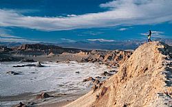
Cordillera de la Sal (Salt Mountains)
- Share:
- Send Friend
- Tweet
Cordillera de la Sal (Salt Mountains) was formed million of years ago. It was an old lake, which bottom went raising by the same movements of the terrestrial coast which gave origin to the Andes Mountains. Moulded through time by rain, wind and the Sun of the Atacama Desert, its final form that we know nowadays counts with a great variety of natural sculptures, different types of stratifications and varied colorations by the mineral diversity of the place.
The name of "Cordillera de la Sal" derives from the fact that its rocks possess a great quantity of calcium sulphate, what gives them the aspect of being splashed with salt.
The fantastic rocks outcrop in the first plane is due to its top and the minerals color of the salt of which they are compound. It is recommendable to see the sunset when the desert changes from red to purple and then black. At heart is the Licancabur volcano which can be seen from hundreds of kilometers away.
Its geologic origin is an emerged lake, where the old horizontal layers are vertical by the fold of the surface. Thus the strange figures that seem dinosaurios arise in a scene of strange brightness. When leaving this mountains, one enters to the Atacama Saltlake; from there is possible to appreciate a panoramic view of the oases that conform San Pedro de Atacama town. Following the way to this town, the Valle de la Muerte (Death Valley) is crossed, with peculiar forms eroded by the wind and a reddish color with white spots.
Cordillera de la Sal is located 70 kilometers from Calama. Just before the entrance to the town of San Pedro de Atacama, it can be seen from both sides; mountains with unusual forms and mineral brights.

 Now! With traveller reviews from