Pukará de Quitor
- Share:
- Send Friend
- Tweet

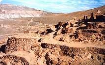
Pukará de Quitor (Fort of Quitor) is located 3 Kms. from San Pedro, over the hill of Quitor. This Pukará was build by the atacameño people to defend themself from other towns that inhabited Southamerica.
Entering Quitor, a fort builded in the XII century lies on the summit of a hill over the river San Pedro. Pukará de Quitor is an ancient indian fortress, which dates from more than 700 years.
Declared National Monument in 1982. Its construction pre-Inca dates from the XII century. Builded over rocks that form the surface of a hill as a fortress with a perimetral defence wall. The ruins of Pukará de Quitor are located in a bend of the bankruptcy where flows the waters of San Pedro river, or Río Grande (Grande river) and over a inclined plane of strong slopes.
It takes its name from the pre-Hispanic group, the "Ayllu de Quitor", whose cultives fields are born on the foot of the Pukará de Quitor, fort erected in the course of the XII century, like an answer to the expansionistic of the Aymaras neighbors .
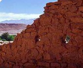
In Quitor, all the constructions are of stone, generally edgeless and extracted from the liparita bank, on which it is seated. The houses and their small attached silo, the defensive enclosures that are noticed in the periphery and assigned to the same defensive wall, the enclosures which store grains and the watchtowers, cover in number of 160 and a surface of 2,5 hectares.
Good part of the described slope has from its contiguous base to the cultive fields to its culminating point, a height of 70 meters. The ceilings are always of only one water, flat or of very little inclination: The same techniques have been used in Quitor and in Lasana: beams of chañar or carob tree, branches, Ichu straw, mud covers.


 Now! With traveller reviews from